
Silverthorne topographic map
Interactive map
Click on the map to display elevation.
About this map
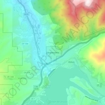
Name: Silverthorne topographic map, elevation, terrain.
Average elevation: 2,883 m
Minimum elevation: 2,620 m
Maximum elevation: 3,682 m
Other topographic maps
Click on a map to view its topography, its elevation and its terrain.
Dillon Reservoir
Vereinigte Staaten von Amerika > Colorado > Silverthorne
Dillon Reservoir, Giberson Bay Road, Dillon, Silverthorne, Summit County, Colorado, 80498, Vereinigte Staaten von Amerika
Average elevation: 2,808 m