
Make a donation
Lampung topographic map
Click on the map to display elevation.
Make a donation
Lampung
Between 1969 and 1970, the total area of forest land in Lampung that had been used was 249,200 hectares. In 2000, there were 48 permits issued; in 1980, the number reached 76 permits. The topography of the region in the western part is mostly hilly, while the eastern part is mostly a lowland area that is agricultural and swampy. In 1950, nine specimens per 100 square kilometres in Lampung were collected as part of botanical research.
Make a donation
About this map
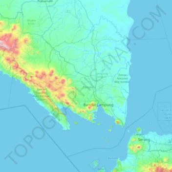
Name: Lampung topographic map, elevation, terrain.
Location: Lampung, Sumatra, Indonesia (-6.45503 103.50688 -3.72374 106.84665)
Average elevation: 111 m
Minimum elevation: -2 m
Maximum elevation: 2,686 m
Make a donation
Other topographic maps
Click on a map to view its topography, its elevation and its terrain.
Make a donation
Make a donation
Bandung
Bandung (Sundanese: ᮘᮔ᮪ᮓᮥᮀ, romanized: Bandung, Sundanese pronunciation: [ˈbandʊŋ]; /ˈbɑːndʊŋ/) is the capital city of the Indonesian province of West Java. It has a population of 2,452,943 within its city limits according to the official estimates as at mid 2021, making it the fourth most…
Average elevation: 893 m
Make a donation
Make a donation
Make a donation
Make a donation
Make a donation
RW 15 KEL. CIHANJUANG RAHAYU KEC. PAROMPONG KAB. BANDUNG BARAT
Indonesia > West Bandung > Cisarua > Villa Istana Bunga
Average elevation: 1,377 m
Make a donation
Make a donation
Make a donation
Make a donation
Make a donation
Make a donation
Make a donation
Make a donation
Make a donation
Make a donation
Make a donation
Make a donation
Make a donation
Ngamprah
Indonesia > West Java > West Bandung
Ngamprah has an elevation moderated tropical rainforest climate (Af) with moderate rainfall from June to September and heavy rainfall from October to May.
Average elevation: 803 m
Ngamprah
Indonesia > West Java > West Bandung
Ngamprah has an elevation moderated tropical rainforest climate (Af) with moderate rainfall from June to September and heavy rainfall from October to May.
Average elevation: 803 m
Make a donation
Make a donation
Make a donation
Make a donation
Make a donation