
Ems topographic map
Interactive map
Click on the map to display elevation.
About this map
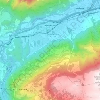
Name: Ems topographic map, elevation, terrain.
Location: Ems, Imboden, Graubünden, 7013, Schweiz (46.79472 9.40616 46.84500 9.49747)
Average elevation: 1,067 m
Minimum elevation: 561 m
Maximum elevation: 2,173 m
Einen wichtigen Platz in der Domat-Emser Kultur nimmt auch die Fasnacht ein. Diese findet während vier Tagen statt und endet am Venergis mellen. Der Höhepunkt ist der Gievgia grassa (schmutziger Donnerstag).
Other topographic maps
Click on a map to view its topography, its elevation and its terrain.
Tamins
Schweiz > Graubünden > Imboden
Tamins, Imboden, Graubünden, 7015, Schweiz
Average elevation: 1,549 m