
Betws Garmon topographic map
Interactive map
Click on the map to display elevation.
About this map
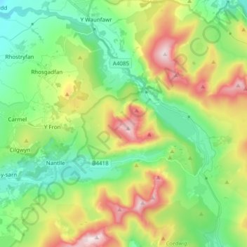
Name: Betws Garmon topographic map, elevation, terrain.
Location: Betws Garmon, Gwynedd, Wales, Verenigd Koninkrijk (53.03075 -4.22682 53.11176 -4.07521)
Average elevation: 285 m
Minimum elevation: 51 m
Maximum elevation: 729 m
Other topographic maps
Click on a map to view its topography, its elevation and its terrain.
Snowdon
Verenigd Koninkrijk > Wales > Gwynedd > Betws Garmon
Snowdon, Llanberis Path, Betws Garmon, Gwynedd, Wales, LL55 4UL, Verenigd Koninkrijk
Average elevation: 692 m