
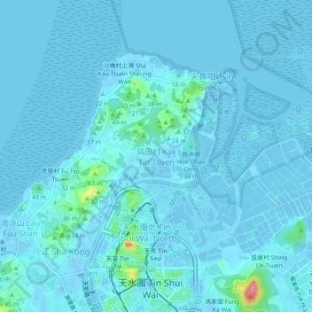
Kak Tin Tsuen topographic map
Interactive map
Click on the map to display elevation.
About this map
Name: Kak Tin Tsuen topographic map, elevation, terrain.
Average elevation: 6 m
Minimum elevation: -14 m
Maximum elevation: 101 m
Other topographic maps
Click on a map to view its topography, its elevation and its terrain.
Lau Fau Shan
China > Hong Kong > Yuen Long District
Lau Fau Shan, Yuen Long District, New Territories, Hong Kong, China
Average elevation: 8 m
Tong Yan San Tsuen
China > Hong Kong > Yuen Long District
Tong Yan San Tsuen, Yuen Long District, New Territories, Hong Kong, China
Average elevation: 20 m
Shan Ha Tsuen
China > Hong Kong > Yuen Long District > Tin Liu Tsuen
Shan Ha Tsuen, Tin Liu Tsuen, Yuen Long District, New Territories, Hong Kong, China
Average elevation: 35 m
Tin Shui Wai
China > Hong Kong > Yuen Long District
Tin Shui Wai, Yuen Long District, New Territories, Hong Kong, China
Average elevation: 20 m
Yuen Long
China > Hong Kong > Yuen Long District
Yuen Long, Yuen Long District, New Territories, Hong Kong, China
Average elevation: 36 m