
Morris Island topographic map
Interactive map
Click on the map to display elevation.
About this map
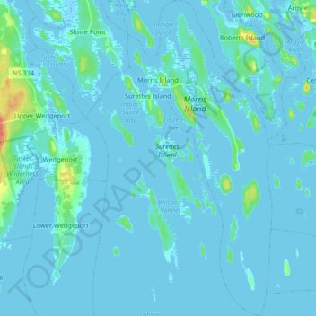
Name: Morris Island topographic map, elevation, terrain.
Average elevation: 3 m
Minimum elevation: -4 m
Maximum elevation: 48 m
Other topographic maps
Click on a map to view its topography, its elevation and its terrain.
Sluice Point
Canada > Nova Scotia > Yarmouth County
Sluice Point, Argyle Municipal District, Yarmouth County, Nova Scotia, B5A 5P7, Canada
Average elevation: 120 m
Indian Bay
Canada > Nova Scotia > Yarmouth County > Abrams River
Indian Bay, Abrams River, Argyle Municipal District, Yarmouth County, Nova Scotia, B0W 3M0, Canada
Average elevation: 4 m
Calf Island
Canada > Nova Scotia > Yarmouth County > East Pubnico
Calf Island, East Pubnico, Argyle Municipal District, Yarmouth County, Nova Scotia, B0W 2W0, Canada
Average elevation: 20 m
Big Gooseberry Island
Canada > Nova Scotia > Yarmouth County > Argyle Sound
Big Gooseberry Island, Argyle Sound, Argyle Municipal District, Yarmouth County, Nova Scotia, Canada
Average elevation: 0 m