
Thank you for supporting this site ❤️
Make a donation
Make a donation
Monticello topographic map
Click on the map to display elevation.
Thank you for supporting this site ❤️
Make a donation
Make a donation
About this map
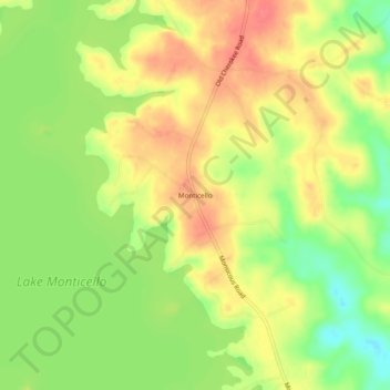
Name: Monticello topographic map, elevation, terrain.
Location: Monticello, Fairfield County, South Carolina, United States (34.33265 -81.31843 34.37265 -81.27843)
Average elevation: 134 m
Minimum elevation: 99 m
Maximum elevation: 163 m
Thank you for supporting this site ❤️
Make a donation
Make a donation
Other topographic maps
Click on a map to view its topography, its elevation and its terrain.