
Rax topographic map
Interactive map
Click on the map to display elevation.
About this map
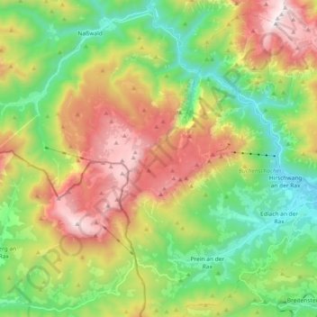
Name: Rax topographic map, elevation, terrain.
Location: Rax, Bezirk Neunkirchen, Neder-Oostenrijk, Oostenrijk (47.65528 15.63957 47.77334 15.82321)
Average elevation: 1,111 m
Minimum elevation: 487 m
Maximum elevation: 2,068 m
Other topographic maps
Click on a map to view its topography, its elevation and its terrain.
Gemeinde Payerbach
Oostenrijk > Neder-Oostenrijk > Bezirk Neunkirchen > Gemeinde Payerbach
Gemeinde Payerbach, Bezirk Neunkirchen, Neder-Oostenrijk, Oostenrijk
Average elevation: 770 m