
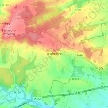
Miermaigne topographic map
Interactive map
Click on the map to display elevation.
About this map
Name: Miermaigne topographic map, elevation, terrain.
Average elevation: 235 m
Minimum elevation: 189 m
Maximum elevation: 281 m
Other topographic maps
Click on a map to view its topography, its elevation and its terrain.
Saussay
France > Centre-Val de Loire > Eure-et-Loir
Saussay, Dreux, Eure-et-Loir, Centre-Val de Loire, France métropolitaine, 28260, France
Average elevation: 80 m
Laons
France > Centre-Val de Loire > Eure-et-Loir
Laons, Dreux, Eure-et-Loir, Centre-Val de Loire, France métropolitaine, 28270, France
Average elevation: 170 m
Le Bois Corbières
France > Centre-Val de Loire > Eure-et-Loir > Bouglainval > Le Grand Gland
Le Bois Corbières, Le Grand Gland, Bouglainval, Chartres, Eure-et-Loir, Centre-Val de Loire, France métropolitaine, 28130, France
Average elevation: 157 m
Houx
France > Centre-Val de Loire > Eure-et-Loir
Houx, Chartres, Eure-et-Loir, Centre-Val de Loire, France métropolitaine, 28130, France
Average elevation: 125 m
Ouerre
France > Centre-Val de Loire > Eure-et-Loir > Ouerre
Ouerre, Dreux, Eure-et-Loir, Centre-Val de Loire, France métropolitaine, 28500, France
Average elevation: 121 m
Maison Forestière de la Grande Noé
France > Centre-Val de Loire > Eure-et-Loir > Châteauneuf-en-Thymerais > Maison Forestière de la Grande Noé
Maison Forestière de la Grande Noé, Châteauneuf-en-Thymerais, Dreux, Eure-et-Loir, Centre-Val de Loire, France métropolitaine, 28170, France
Average elevation: 204 m
Chaudon
France > Centre-Val de Loire > Eure-et-Loir > Chaudon
Chaudon, Dreux, Eure-et-Loir, Centre-Val de Loire, France métropolitaine, 28210, France
Average elevation: 119 m