
Thank you for supporting this site ❤️
Make a donation
Make a donation
Itlay Hisage topographic map
Click on the map to display elevation.
Thank you for supporting this site ❤️
Make a donation
Make a donation
About this map
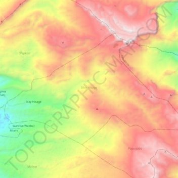
Name: Itlay Hisage topographic map, elevation, terrain.
Average elevation: 2,943 m
Minimum elevation: 1,837 m
Maximum elevation: 3,941 m
Thank you for supporting this site ❤️
Make a donation
Make a donation
Other topographic maps
Click on a map to view its topography, its elevation and its terrain.
Wamena
Indonesia > Highland Papua > Jayawijaya
Wamena features a tropical rainforest climate (Köppen Af), albeit a relatively mild version due to its high altitude.
Average elevation: 2,287 m
Thank you for supporting this site ❤️
Make a donation
Make a donation