
East Nile topographic map
Interactive map
Click on the map to display elevation.
About this map
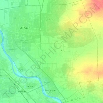
Name: East Nile topographic map, elevation, terrain.
Location: East Nile, Khartoum State, Sudan (15.46878 32.57502 15.67511 32.78964)
Average elevation: 392 m
Minimum elevation: 374 m
Maximum elevation: 424 m
Other topographic maps
Click on a map to view its topography, its elevation and its terrain.
Khartoum
Sudan > Khartoum State > Khartoum
Khartoum is relatively flat, at elevation 385 m (1,263 ft), as the Nile flows northeast past Omdurman to Shendi, at elevation 364 m (1,194 ft)about 101 miles (163 km) away.
Average elevation: 388 m