
Neige et Soleil topographic map
Interactive map
Click on the map to display elevation.
About this map
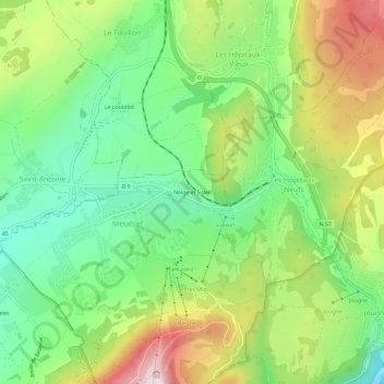
Name: Neige et Soleil topographic map, elevation, terrain.
Average elevation: 1,049 m
Minimum elevation: 869 m
Maximum elevation: 1,326 m
Other topographic maps
Click on a map to view its topography, its elevation and its terrain.
Lac du Morond
France > Bourgogne-Franche-Comté > Doubs > Métabief
Lac du Morond, Métabief, Pontarlier, Doubs, Bourgogne-Franche-Comté, France métropolitaine, 25370, France
Average elevation: 1,178 m