
Val Veny topographic map
Interactive map
Click on the map to display elevation.
About this map
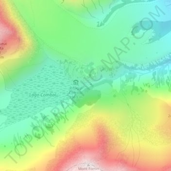
Name: Val Veny topographic map, elevation, terrain.
Location: Val Veny, Courmayeur, Valle d'Aosta, Italië (45.76587 6.85992 45.78587 6.87992)
Average elevation: 2,151 m
Minimum elevation: 1,801 m
Maximum elevation: 2,755 m
Other topographic maps
Click on a map to view its topography, its elevation and its terrain.
Lechey Desot
Italië > Valle d'Aosta > Courmayeur
Lechey Desot, Courmayeur, Valle d'Aosta, 11013, Italië
Average elevation: 1,814 m
Peindein
Italië > Valle d'Aosta > Courmayeur > Peindein
Peindein, Courmayeur, Valle d'Aosta, 11013, Italië
Average elevation: 1,741 m
Picco Luigi Amedeo
Italië > Valle d'Aosta > Courmayeur
Picco Luigi Amedeo, Courmayeur, Valle d'Aosta, Italië
Average elevation: 3,790 m