
Hemmersdorf topographic map
Interactive map
Click on the map to display elevation.
About this map
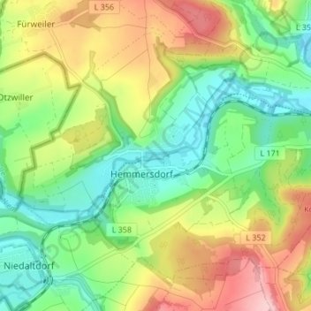
Name: Hemmersdorf topographic map, elevation, terrain.
Average elevation: 255 m
Minimum elevation: 172 m
Maximum elevation: 380 m
Other topographic maps
Click on a map to view its topography, its elevation and its terrain.
Biringen
Deutschland > Saarland > Landkreis Saarlouis > Rehlingen-Siersburg
Biringen, Rehlingen-Siersburg, Landkreis Saarlouis, Saarland, Deutschland
Average elevation: 308 m
Fürweiler
Deutschland > Saarland > Landkreis Saarlouis > Rehlingen-Siersburg
Fürweiler, Rehlingen-Siersburg, Landkreis Saarlouis, Saarland, Deutschland
Average elevation: 293 m