
Make a donation
Teufelsmauer topographic map
Click on the map to display elevation.
Make a donation
About this map
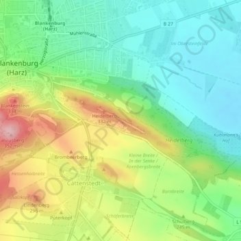
Name: Teufelsmauer topographic map, elevation, terrain.
Average elevation: 222 m
Minimum elevation: 158 m
Maximum elevation: 332 m
Make a donation
Other topographic maps
Click on a map to view its topography, its elevation and its terrain.
Heimburg
Deutschland > Sachsen-Anhalt > Landkreis Harz > Blankenburg
Unmittelbar nördlich des Dorfs liegt eine Anhöhe, auf der sich die Überreste der ehemaligen Burg Heimburg, auch Altenburg genannt, und ein Aussichtspunkt befinden. Zudem liegt Heimburg am Fuß der Hügelkette von Ziegenberg (315,7 m) und Struvenberg (305,7 m), die sich in Richtung Nordwesten bis…
Average elevation: 301 m
Make a donation
Börnecke
Deutschland > Sachsen-Anhalt > Landkreis Harz > Blankenburg
Börnecke liegt etwa sechs Kilometer nordöstlich des Stadtzentrums von Blankenburg. Etwa acht Kilometer nördlich befindet sich die Kreisstadt des Landkreises Harz, Halberstadt, etwa neun Kilometer südöstlich die Weltkulturerbestadt Quedlinburg und etwa acht Kilometer südlich die Stadt Thale. Das Dorf ist…
Average elevation: 176 m
Ziegenkopf
Deutschland > Sachsen-Anhalt > Landkreis Harz > Blankenburg
Vor über 100 Jahren wurde auf der Bergkuppe des Ziegenkopfs der steinerne und im oberen Teil mit Holz verkleidete Aussichtsturm Ziegenkopfturm mit 30 m Höhe errichtet, der eine gute Rundumsicht bis hin zum Brocken bietet. Direkt an den Turm angegliedert ist der Berggasthof Ziegenkopf.
Average elevation: 331 m
Make a donation