
Make a donation
Darlag County topographic map
Click on the map to display elevation.
Make a donation
Darlag County
With an elevation of around 3,970 metres (13,020 ft), Darlag County has an alpine climate (Köppen ET), bordering on a subalpine climate (Köppen Cwc), with long, very cold winters, and short, rainy, cool summers. Average low temperatures are below freezing from mid September to late May; however, due to the wide diurnal temperature variation, average highs are only below freezing from mid/late November thru early March. With monthly percent possible sunshine ranging from 47% in June to 70% in November, the county seat receives 2,467 hours of bright sunshine annually. The monthly 24-hour average temperature ranges from −12.0 °C (10.4 °F) in January to 9.8 °C (49.6 °F) in July, while the annual mean is −0.53 °C (31.0 °F). Over 70% of the annual precipitation of 558 mm (22.0 in) is delivered from June to September.
Make a donation
About this map
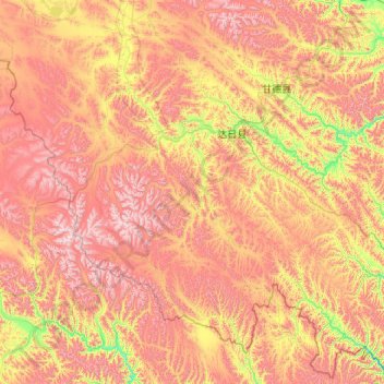
Name: Darlag County topographic map, elevation, terrain.
Location: Darlag County, Golog, Qinghai, China (32.72589 98.39111 34.23247 100.54186)
Average elevation: 4,391 m
Minimum elevation: 3,781 m
Maximum elevation: 5,216 m
Make a donation
Other topographic maps
Click on a map to view its topography, its elevation and its terrain.