
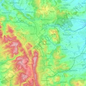
Horn-Bad Meinberg topographic map
Interactive map
Click on the map to display elevation.
About this map
Name: Horn-Bad Meinberg topographic map, elevation, terrain.
Average elevation: 238 m
Minimum elevation: 131 m
Maximum elevation: 464 m
In the municipality are the two highest peaks of the Eggegebirge, the Lipp Velmerstot (441 m) and the Prussian Velmerstot with about (464 m) above sea level and the highest elevation of the Teutoburg forest, the Barnacken with (446 m). The deepest point of the metropolitan area is (125 m). Between the districts Horn and Holzhausen-Externsteine is the most famous natural monument of the Teutoburg Forest, the Externsteine, nearby springs the Wiembecke.
Other topographic maps
Click on a map to view its topography, its elevation and its terrain.
Horn-Bad Meinberg
Germany > North Rhine-Westphalia > Kreis Lippe
Horn-Bad Meinberg, Kreis Lippe, North Rhine-Westphalia, 32805, Germany
Average elevation: 240 m
Lügde
Germany > North Rhine-Westphalia > Kreis Lippe
Lügde, Kreis Lippe, North Rhine-Westphalia, Germany
Average elevation: 196 m
Lemgo
Germany > North Rhine-Westphalia > Kreis Lippe
Lemgo, Kreis Lippe, North Rhine-Westphalia, 32657, Germany
Average elevation: 173 m
Detmold
Germany > North Rhine-Westphalia > Kreis Lippe
Detmold, Kreis Lippe, North Rhine-Westphalia, Germany
Average elevation: 202 m