
Yungay topographic map
Interactive map
Click on the map to display elevation.
About this map
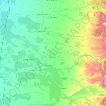
Name: Yungay topographic map, elevation, terrain.
Location: Yungay, Provincia de Diguillín, Ñuble Region, Chile (-37.19718 -72.27985 -36.99854 -71.53989)
Average elevation: 367 m
Minimum elevation: 65 m
Maximum elevation: 1,643 m
Even though the total area of the commune is around 823 km squared, only 3.87 km squared (0.47% of the total territory) has been urbanized: the cities of Yungay (with 9,288 inhabitants as of 2002) and Campanario. In the 2017 census there were 17,787 total inhabitants in the commune. The Yungay Commune is located on the eastern borders of the region, thus it contains parts of the Cordillera of the Andes, where the altitude reaches between 150 and 2000 meters above sea level. Several rivers flow out of the Andes sector and cross the body of the region. Generally, the land is devoted to agricultural purposes, principally the growth of California Pine, wheat, oats, or lentils; or for livestock grazing.
Other topographic maps
Click on a map to view its topography, its elevation and its terrain.
Las Esquinas
Chile > Ñuble Region > Provincia de Diguillín > Bulnes
Las Esquinas, Bulnes, Provincia de Diguillín, Ñuble Region, Chile
Average elevation: 68 m
Quillón
Chile > Ñuble Region > Provincia de Diguillín
Quillón, Provincia de Diguillín, Ñuble Region, Chile
Average elevation: 140 m
Chillán Viejo
Chile > Ñuble Region > Provincia de Diguillín
Chillán Viejo, Provincia de Diguillín, Ñuble Region, 3820000, Chile
Average elevation: 133 m
Pinto
Chile > Ñuble Region > Provincia de Diguillín
Pinto, Provincia de Diguillín, Ñuble Region, 3880000, Chile
Average elevation: 545 m
Chillán
Chile > Ñuble Region > Provincia de Diguillín > Chillán
Chillán, Provincia de Diguillín, Ñuble Region, 056, Chile
Average elevation: 139 m
Chillán
Chile > Ñuble Region > Provincia de Diguillín
Chillán, Provincia de Diguillín, Ñuble Region, Chile
Average elevation: 166 m