
Couvin topographic map
Interactive map
Click on the map to display elevation.
About this map
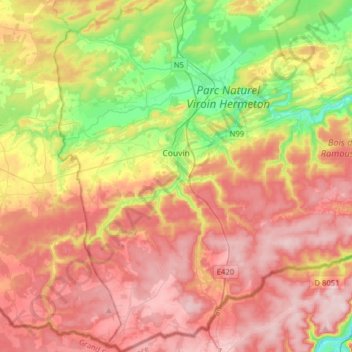
Name: Couvin topographic map, elevation, terrain.
Location: Couvin, Philippeville, Namur, Wallonien, 5660, Belgien (49.93722 4.38579 50.14001 4.60525)
Average elevation: 270 m
Minimum elevation: 119 m
Maximum elevation: 403 m
Other topographic maps
Click on a map to view its topography, its elevation and its terrain.
Marienburg
Belgien > Namur > Philippeville > Couvin
Marienburg, Couvin, Philippeville, Namur, Wallonien, 5660, Belgien
Average elevation: 172 m
Clermont
Belgien > Namur > Philippeville > Clermont
Clermont, Walcourt, Philippeville, Namur, Wallonien, 5650, Belgien
Average elevation: 191 m