
Quellental Wingst topographic map
Interactive map
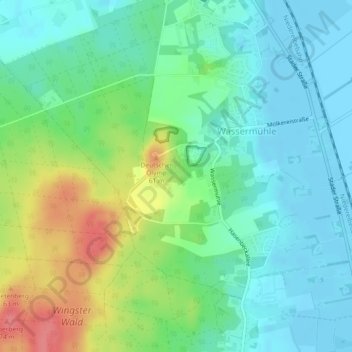
Click on the map to display elevation.
About this map
Name: Quellental Wingst topographic map, elevation, terrain.
Average elevation: 22 m
Minimum elevation: -3 m
Maximum elevation: 71 m
Other topographic maps
Click on a map to view its topography, its elevation and its terrain.
Höden
Deutschland > Niedersachsen > Landkreis Cuxhaven > Wingst
Höden, Wingst, Samtgemeinde Land Hadeln, Landkreis Cuxhaven, Niedersachsen, 21781, Deutschland
Average elevation: 7 m
Zollbaum
Deutschland > Niedersachsen > Landkreis Cuxhaven > Wingst > Zollbaum
Zollbaum, Wingst, Samtgemeinde Land Hadeln, Landkreis Cuxhaven, Niedersachsen, 21782, Deutschland
Average elevation: 7 m
Balksee
Deutschland > Niedersachsen > Landkreis Cuxhaven > Wingst
Balksee, Wingst, Samtgemeinde Land Hadeln, Landkreis Cuxhaven, Niedersachsen, 21789, Deutschland
Average elevation: 0 m