
Santa Rosa de Yavari topographic map
Interactive map
Click on the map to display elevation.
About this map
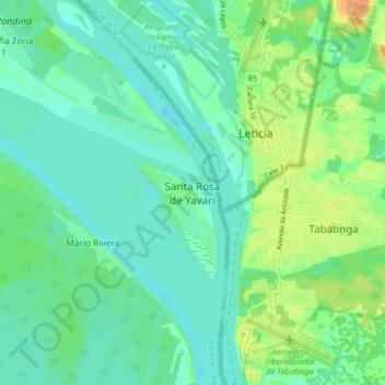
Name: Santa Rosa de Yavari topographic map, elevation, terrain.
Average elevation: 68 m
Minimum elevation: 57 m
Maximum elevation: 93 m
Other topographic maps
Click on a map to view its topography, its elevation and its terrain.
Nueva Nazareth
Nueva Nazareth, Yavari, Mariscal Ramón Castilla, Loreto, Perú
Average elevation: 76 m
Soplin Vargas
Perú > Loreto > Yavari > Soplin Vargas
Soplin Vargas, Yavari, Provincia de Mariscal Ramón Castilla, Loreto, Perú
Average elevation: 75 m
San Sebastian
Perú > Loreto > Yavari > San Sebastian
San Sebastian, Yavari, Provincia de Mariscal Ramón Castilla, Loreto, Perú
Average elevation: 83 m