
Make a donation
Darkhan-Uul topographic map
Click on the map to display elevation.
Make a donation
Darkhan-Uul
Darkhan Uul Aimag is situated in the agricultural heartland of Mongolia and it is a major agricultural producer in Mongolia with rich resources for agricultural development. This area, located at a low altitude, has a warmer climate than the rest of the country. In the Kharaa River basin there are favorable natural climatic conditions for the cultivation of cereals, vegetables, and especially potatoes. There are 35 agricultural companies and co-operatives in Darkhan Uul Aimag. This area contains 30,000 hectares of soil suitable for arable farming and 1287.8 thousand hectares for vegetable farming. Despite the development of the urban economy, local people continue to keep livestock. There are approximately 130,000 head of livestock in the province.
Make a donation
About this map
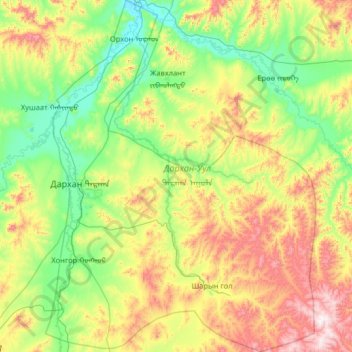
Name: Darkhan-Uul topographic map, elevation, terrain.
Location: Darkhan-Uul, Mongolia (49.08735 105.80842 49.92808 106.80389)
Average elevation: 909 m
Minimum elevation: 629 m
Maximum elevation: 1,634 m
Make a donation
Other topographic maps
Click on a map to view its topography, its elevation and its terrain.
Ulaanbaatar
Mongolia > Ulaanbaatar > Ulaanbaatar
Ulaanbaatar (/ˌuːlɑːn ˈbɑːtər/; Mongolian: Улаанбаатар, , lit. "Red Hero"), previously anglicized as Ulan Bator, is the capital and most populous city of Mongolia. The municipality is located in north central Mongolia at an elevation of about 1,300 metres (4,300 ft) in a valley on the Tuul…
Average elevation: 1,541 m