
Seth topographic map
Interactive map
Click on the map to display elevation.
About this map
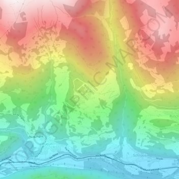
Name: Seth topographic map, elevation, terrain.
Average elevation: 1,275 m
Minimum elevation: 701 m
Maximum elevation: 2,040 m
Das Haufendorf liegt auf einer Terrasse hoch über dem linken Ufer des Vorderrheins. Die Gemeinde reicht von 930 m ü. M. nördlich von Rueun und Schnaus bis auf eine Höhe von 2833 m in der Nähe des Vorab an der Grenze zum Kanton Glarus. Vom gesamten Gemeindegebiet von 1348 ha sind 689 ha landwirtschaftlich nutzbar, darunter sind 565 ha Maiensässen. 453 ha des Gemeindeareals sind von Wald und Gehölz bedeckt und 180 ha unproduktive Fläche (Gebirge). Die restlichen 26 ha sind Siedlungsfläche.
Other topographic maps
Click on a map to view its topography, its elevation and its terrain.
Ilanz
Schweiz > Graubünden > Surselva > Ilanz/Glion
Ilanz, Ilanz/Glion, Suraua, Surselva, Graubünden, 7130, Schweiz
Average elevation: 1,214 m