
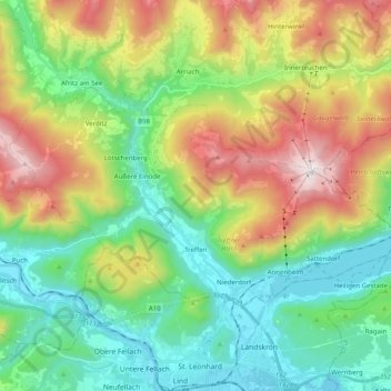
Treffen am Ossiacher See topographic map
Interactive map
Click on the map to display elevation.
About this map
Name: Treffen am Ossiacher See topographic map, elevation, terrain.
Average elevation: 967 m
Minimum elevation: 483 m
Maximum elevation: 1,909 m
Other topographic maps
Click on a map to view its topography, its elevation and its terrain.
Finkenstein am Faaker See
Österreich > Kärnten > Bezirk Villach-Land
Finkenstein am Faaker See, Bezirk Villach-Land, Kärnten, 9584, Österreich
Average elevation: 909 m
Sattendorf
Österreich > Kärnten > Bezirk Villach-Land
Sattendorf, Treffen am Ossiacher See, Bezirk Villach-Land, Kärnten, 9521, Österreich
Average elevation: 824 m
Insberg
Österreich > Kärnten > Bezirk Villach-Land > Rudersdorf
Insberg, Rudersdorf, Ferndorf, Bezirk Villach-Land, Kärnten, 9702, Österreich
Average elevation: 697 m
Ferndorf
Österreich > Kärnten > Bezirk Villach-Land
Ferndorf, Bezirk Villach-Land, Kärnten, 9702, Österreich
Average elevation: 754 m
Faaker See
Österreich > Kärnten > Bezirk Villach-Land > Finkenstein am Faaker See > Faak am See
Faaker See, Faak am See, Finkenstein am Faaker See, Bezirk Villach-Land, Kärnten, 9584, Österreich
Average elevation: 572 m
Mittagskogel
Österreich > Kärnten > Bezirk Villach-Land > Finkenstein am Faaker See
Mittagskogel, Finkenstein am Faaker See, Bezirk Villach-Land, Kärnten, 9584, Österreich
Average elevation: 1,574 m
Arriach
Österreich > Kärnten > Bezirk Villach-Land
Arriach, Bezirk Villach-Land, Kärnten, 9543, Österreich
Average elevation: 1,324 m
Rudersdorf
Österreich > Kärnten > Bezirk Villach-Land
Rudersdorf, Ferndorf, Bezirk Villach-Land, Kärnten, 9702, Österreich
Average elevation: 664 m
Kärntner Törl
Österreich > Kärnten > Bezirk Villach-Land > St. Jakob im Rosental
Kärntner Törl, St. Jakob im Rosental, Bezirk Villach-Land, Kärnten, 9183, Österreich
Average elevation: 1,456 m
Innerteuchen
Österreich > Kärnten > Bezirk Villach-Land
Innerteuchen, Arriach, Bezirk Villach-Land, Kärnten, 9543, Österreich
Average elevation: 1,203 m
Maria Elend
Österreich > Kärnten > Bezirk Villach-Land > St. Jakob im Rosental
Maria Elend, St. Jakob im Rosental, Bezirk Villach-Land, Kärnten, 9182, Österreich
Average elevation: 585 m
Ziebl
Österreich > Kärnten > Bezirk Villach-Land
Ziebl, Stockenboi, Bezirk Villach-Land, Kärnten, 9714, Österreich
Average elevation: 688 m
Stockenboi
Österreich > Kärnten > Bezirk Villach-Land
Stockenboi, Bezirk Villach-Land, Kärnten, 9714, Österreich
Average elevation: 1,172 m
Gschriet
Österreich > Kärnten > Bezirk Villach-Land > Ferndorf
Gschriet, Ferndorf, Bezirk Villach-Land, Kärnten, 9702, Österreich
Average elevation: 1,060 m
Stadelbach
Österreich > Kärnten > Bezirk Villach-Land
Stadelbach, Weißenstein, Bezirk Villach-Land, Kärnten, 9721, Österreich
Average elevation: 668 m
Lerchbach
Österreich > Kärnten > Bezirk Villach-Land > Bad Bleiberg > Bleiberg-Kreuth
Lerchbach, Bleiberg-Kreuth, Bad Bleiberg, Bezirk Villach-Land, Kärnten, 9530, Österreich
Average elevation: 1,000 m
Lind
Österreich > Kärnten > Bezirk Villach-Land > Arnoldstein
Lind, Arnoldstein, Bezirk Villach-Land, Kärnten, 9587, Österreich
Average elevation: 711 m
Verditz
Österreich > Kärnten > Bezirk Villach-Land
Verditz, Treffen am Ossiacher See, Bezirk Villach-Land, Kärnten, 9521, Österreich
Average elevation: 963 m
Neufeld
Österreich > Kärnten > Bezirk Villach-Land > Finkenstein am Faaker See > Techanting
Neufeld, Techanting, Finkenstein am Faaker See, Bezirk Villach-Land, Kärnten, 9584, Österreich
Average elevation: 579 m
Göriach
Österreich > Kärnten > Bezirk Villach-Land > Velden am Wörther See > Kranzlhofen > Göriach
Göriach, Kranzlhofen, Velden am Wörther See, Bezirk Villach-Land, Kärnten, 9220, Österreich
Average elevation: 587 m
Velden am Wörther See
Österreich > Kärnten > Bezirk Villach-Land
Velden am Wörther See, Bezirk Villach-Land, Kärnten, Österreich
Average elevation: 612 m
Hochegg
Österreich > Kärnten > Bezirk Villach-Land > Stockenboi
Hochegg, Stockenboi, Bezirk Villach-Land, Kärnten, 9714, Österreich
Average elevation: 874 m
Gerlitzen
Österreich > Kärnten > Bezirk Villach-Land > Arriach
Gerlitzen, Arriach, Bezirk Villach-Land, Kärnten, 9543, Österreich
Average elevation: 1,631 m
Bad Bleiberg
Österreich > Kärnten > Bezirk Villach-Land
Bad Bleiberg, Bezirk Villach-Land, Kärnten, 9530, Österreich
Average elevation: 911 m