
Taloire topographic map
Interactive map
Click on the map to display elevation.
About this map
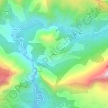
Name: Taloire topographic map, elevation, terrain.
Average elevation: 925 m
Minimum elevation: 641 m
Maximum elevation: 1,609 m
Other topographic maps
Click on a map to view its topography, its elevation and its terrain.
La Lagne
France > Provence-Alpes-Côte d'Azur > Alpes-de-Haute-Provence > Castellane
La Lagne, Castellane, Alpes-de-Haute-Provence, Provence-Alpes-Côte d'Azur, France métropolitaine, 04120, France
Average elevation: 983 m
Château de Soleils
France > Provence-Alpes-Côte d'Azur > Alpes-de-Haute-Provence > Castellane
Château de Soleils, Castellane, Alpes-de-Haute-Provence, Provence-Alpes-Côte d'Azur, France métropolitaine, 04120, France
Average elevation: 922 m
Chasteuil
France > Provence-Alpes-Côte d'Azur > Alpes-de-Haute-Provence > Castellane
Chasteuil, Castellane, Alpes-de-Haute-Provence, Provence-Alpes-Côte d'Azur, France métropolitaine, 04120, France
Average elevation: 1,143 m
La Palud
France > Provence-Alpes-Côte d'Azur > Alpes-de-Haute-Provence > Castellane
La Palud, Castellane, Alpes-de-Haute-Provence, Provence-Alpes-Côte d'Azur, France métropolitaine, 04120, France
Average elevation: 965 m
Cheiron
France > Provence-Alpes-Côte d'Azur > Alpes-de-Haute-Provence > Castellane
Cheiron, Castellane, Alpes-de-Haute-Provence, Provence-Alpes-Côte d'Azur, France métropolitaine, 04120, France
Average elevation: 1,015 m
Villars Brandis
France > Provence-Alpes-Côte d'Azur > Alpes-de-Haute-Provence > Castellane
Villars Brandis, Castellane, Alpes-de-Haute-Provence, Provence-Alpes-Côte d'Azur, France métropolitaine, 04120, France
Average elevation: 1,029 m
La Baume
France > Provence-Alpes-Côte d'Azur > Alpes-de-Haute-Provence > Castellane
La Baume, Castellane, Alpes-de-Haute-Provence, Provence-Alpes-Côte d'Azur, France métropolitaine, 04120, France
Average elevation: 1,195 m
Sionne
France > Provence-Alpes-Côte d'Azur > Alpes-de-Haute-Provence > Castellane
Sionne, Castellane, Alpes-de-Haute-Provence, Provence-Alpes-Côte d'Azur, France métropolitaine, 04120, France
Average elevation: 1,148 m
Le Petit Robion
France > Provence-Alpes-Côte d'Azur > Alpes-de-Haute-Provence > Castellane
Le Petit Robion, Castellane, Alpes-de-Haute-Provence, Provence-Alpes-Côte d'Azur, France métropolitaine, 04120, France
Average elevation: 1,064 m