
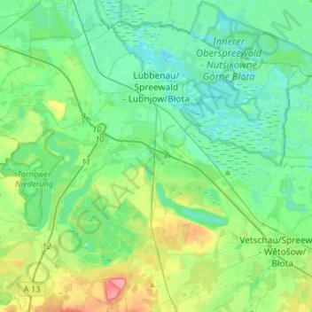
Lübbenau/Spreewald topographic map
Interactive map
Click on the map to display elevation.
About this map
Name: Lübbenau/Spreewald topographic map, elevation, terrain.
Average elevation: 60 m
Minimum elevation: 41 m
Maximum elevation: 116 m
Das Stadtgebiet von Lübbenau umfasst eine Fläche von 13.942 Hektar. Davon sind, Stand 2019, 1858 Hektar (13,3 %) Siedlungsfläche, 609 Hektar (4,4 %) Verkehrsfläche, 10.873 Hektar (78,0 %) Wiesen- und Ackerland sowie 602 Hektar (4,3 %) Gewässerfläche. Damit weist die Stadt höheren Anteil an Wasserfläche auf als das Land Brandenburg insgesamt (3,4 %).
Other topographic maps
Click on a map to view its topography, its elevation and its terrain.
Calau
Deutschland > Brandenburg > Oberspreewald-Lausitz
Calau, Oberspreewald-Lausitz, Brandenburg, 03205, Deutschland
Average elevation: 83 m
Weißag
Deutschland > Brandenburg > Oberspreewald-Lausitz > Luckaitztal
Weißag, Luckaitztal, Altdöbern, Oberspreewald-Lausitz, Brandenburg, 03229, Deutschland
Average elevation: 127 m
Koßwig
Deutschland > Brandenburg > Oberspreewald-Lausitz > Vetschau/Spreewald
Koßwig, Vetschau/Spreewald, Oberspreewald-Lausitz, Brandenburg, Deutschland
Average elevation: 67 m
Senftenberg
Deutschland > Brandenburg > Oberspreewald-Lausitz
Senftenberg, Oberspreewald-Lausitz, Brandenburg, Deutschland
Average elevation: 110 m
Hohenbocka
Deutschland > Brandenburg > Oberspreewald-Lausitz
Hohenbocka, Ruhland, Oberspreewald-Lausitz, Brandenburg, Deutschland
Average elevation: 126 m
Lauchhammer
Deutschland > Brandenburg > Oberspreewald-Lausitz > Lauchhammer
Lauchhammer, Oberspreewald-Lausitz, Brandenburg, 01979, Deutschland
Average elevation: 107 m