
Gemeinde Assling topographic map
Interactive map
Click on the map to display elevation.
About this map
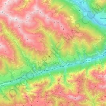
Name: Gemeinde Assling topographic map, elevation, terrain.
Location: Gemeinde Assling, Bezirk Lienz, Tirol, 9911, Österreich (46.73868 12.50409 46.85931 12.71048)
Average elevation: 1,688 m
Minimum elevation: 680 m
Maximum elevation: 2,761 m
Das Gemeindegebiet erstreckt sich dabei auf beide Talseiten des Pustertals, bewohnt ist jedoch nur der Nordteil an der Pustertaler Höhenstraße und der enge Talabschnitt der Drau.
Other topographic maps
Click on a map to view its topography, its elevation and its terrain.
Debanttal
Österreich > Tirol > Bezirk Lienz > Nußdorf-Debant
Debanttal, Nußdorf-Debant, Bezirk Lienz, Tirol, Österreich
Average elevation: 1,741 m
Tristach
Österreich > Tirol > Bezirk Lienz
Tristach, Bezirk Lienz, Tirol, 9907, Österreich
Average elevation: 1,415 m
Panzendorf
Österreich > Tirol > Bezirk Lienz
Panzendorf, Gemeinde Heinfels, Bezirk Lienz, Tirol, 9919, Österreich
Average elevation: 1,345 m
Marktgemeinde Sillian
Österreich > Tirol > Bezirk Lienz
Marktgemeinde Sillian, Bezirk Lienz, Tirol, 9920, Österreich
Average elevation: 1,702 m
Lienz
Österreich > Tirol > Bezirk Lienz > Stadt Lienz
Lienz, Stadt Lienz, Bezirk Lienz, Tirol, 9900, Österreich
Average elevation: 1,050 m
Gemeinde Obertilliach
Österreich > Tirol > Bezirk Lienz
Gemeinde Obertilliach, Bezirk Lienz, Tirol, 9942, Österreich
Average elevation: 1,853 m
Gemeinde Oberlienz
Österreich > Tirol > Bezirk Lienz
Gemeinde Oberlienz, Bezirk Lienz, Tirol, 9903, Österreich
Average elevation: 1,554 m
Gemeinde Ainet
Österreich > Tirol > Bezirk Lienz
Gemeinde Ainet, Bezirk Lienz, Tirol, 9951, Österreich
Average elevation: 1,843 m
Gemeinde Innervillgraten
Österreich > Tirol > Bezirk Lienz > Gemeinde Innervillgraten
Gemeinde Innervillgraten, Bezirk Lienz, Tirol, 9932, Österreich
Average elevation: 2,170 m
Erlach
Österreich > Tirol > Bezirk Lienz > Gemeinde Sankt Jakob in Defereggen > St. Jakob
Erlach, St. Jakob, Gemeinde Sankt Jakob in Defereggen, Bezirk Lienz, Tirol, 9963, Österreich
Average elevation: 1,819 m
Gschlößtal
Österreich > Tirol > Bezirk Lienz > Marktgemeinde Matrei in Osttirol > Außergschlöß
Gschlößtal, Außergschlöß, Marktgemeinde Matrei in Osttirol, Bezirk Lienz, Tirol, Österreich
Average elevation: 2,434 m
Graukogel
Österreich > Tirol > Bezirk Lienz > Marktgemeinde Matrei in Osttirol
Graukogel, Marktgemeinde Matrei in Osttirol, Bezirk Lienz, Tirol, Österreich
Average elevation: 2,650 m
Hirschbichl
Österreich > Tirol > Bezirk Lienz > Gemeinde Sankt Jakob in Defereggen
Hirschbichl, Gemeinde Sankt Jakob in Defereggen, Bezirk Lienz, Tirol, Österreich
Average elevation: 1,989 m
Hochpustertal
Österreich > Tirol > Bezirk Lienz
Hochpustertal, Bezirk Lienz, Tirol, 9920, Österreich
Average elevation: 1,855 m
Gemeinde Kartitsch
Österreich > Tirol > Bezirk Lienz > Gemeinde Kartitsch
Gemeinde Kartitsch, Bezirk Lienz, Tirol, 9941, Österreich
Average elevation: 1,854 m
Gassen
Österreich > Tirol > Bezirk Lienz > Gemeinde St. Veit in Defereggen > Gassen
Gassen, Gemeinde St. Veit in Defereggen, Bezirk Lienz, Tirol, 9962, Österreich
Average elevation: 1,796 m
Gemeinde Untertilliach
Österreich > Tirol > Bezirk Lienz > Gemeinde Untertilliach
Gemeinde Untertilliach, Bezirk Lienz, Tirol, 9943, Österreich
Average elevation: 1,784 m
Hollbruck
Österreich > Tirol > Bezirk Lienz > Gemeinde Kartitsch > Hollbruck
Hollbruck, Gemeinde Kartitsch, Bezirk Lienz, Tirol, 9919, Österreich
Average elevation: 1,379 m
Prägraten
Österreich > Tirol > Bezirk Lienz > Gemeinde Prägraten am Großvenediger
Prägraten, Gemeinde Prägraten am Großvenediger, Bezirk Lienz, Tirol, 9974, Österreich
Average elevation: 1,789 m
Klaunz
Österreich > Tirol > Bezirk Lienz > Marktgemeinde Matrei in Osttirol
Klaunz, Marktgemeinde Matrei in Osttirol, Bezirk Lienz, Tirol, 9971, Österreich
Average elevation: 1,292 m
Gemeinde Virgen
Österreich > Tirol > Bezirk Lienz
Gemeinde Virgen, Bezirk Lienz, Tirol, 9972, Österreich
Average elevation: 2,047 m