
Make a donation
Schielo topographic map
Click on the map to display elevation.
Make a donation
Schielo
Alexisbad mit Hänichen und Klostermühle | Dankerode | Stadt Güntersberge mit Bärenrode und Friedrichshöhe | Harzgerode | Königerode | Mägdesprung | Neudorf | Schielo | Silberhütte | Siptenfelde | Straßberg mit Lindenberg
Make a donation
About this map
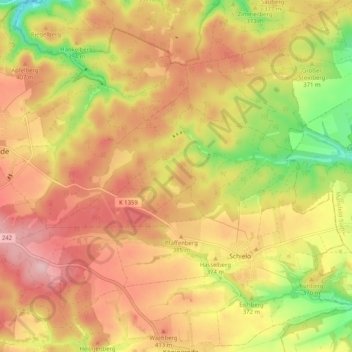
Name: Schielo topographic map, elevation, terrain.
Average elevation: 372 m
Minimum elevation: 261 m
Maximum elevation: 452 m
Make a donation
Other topographic maps
Click on a map to view its topography, its elevation and its terrain.
Silberhütte
Deutschland > Sachsen-Anhalt > Landkreis Harz > Harzgerode
Alexisbad mit Hänichen und Klostermühle | Dankerode | Stadt Güntersberge mit Bärenrode und Friedrichshöhe | Harzgerode | Königerode | Mägdesprung | Neudorf | Schielo | Silberhütte | Siptenfelde | Straßberg mit Lindenberg
Average elevation: 396 m
Make a donation