
Murten topographic map
Interactive map
Click on the map to display elevation.
About this map
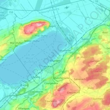
Name: Murten topographic map, elevation, terrain.
Location: Murten, Seebezirk, Freiburg, Schweiz (46.88224 7.08265 46.98633 7.21044)
Average elevation: 480 m
Minimum elevation: 423 m
Maximum elevation: 652 m
Murten liegt auf 453 m ü. M., 14 km nördlich der Kantonshauptstadt Freiburg (Luftlinie). Die Stadt erstreckt sich auf einer rund 20 m hohen Anhöhe am Südostufer des Murtensees, östlich der Mündung des von Münchenwiler herkommenden Baches, im nördlichen Freiburger Mittelland.
Other topographic maps
Click on a map to view its topography, its elevation and its terrain.