
KABUPATEN BANGLI topographic map
Interactive map
Click on the map to display elevation.
About this map
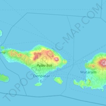
Name: KABUPATEN BANGLI topographic map, elevation, terrain.
Location: KABUPATEN BANGLI, Bali, Indonésie (-9.22495 114.43841 -7.22495 116.43841)
Average elevation: 74 m
Minimum elevation: 0 m
Maximum elevation: 3,051 m
Other topographic maps
Click on a map to view its topography, its elevation and its terrain.
Parc national de Bali occidental
Indonésie > Bali > Buleleng > Labuhan Lalang
Parc national de Bali occidental, Labuhan Lalang, Buleleng, Bali, Nusa Tenggara, 82253, Indonésie
Average elevation: 66 m
Dauh Puri Kangin
Indonésie > Bali > Denpasar > Dauh Puri Kangin
Dauh Puri Kangin, Denpasar Barat, Denpasar, Bali, 80232, Indonésie
Average elevation: 26 m