
Allegan Township topographic map
Interactive map
Click on the map to display elevation.
About this map
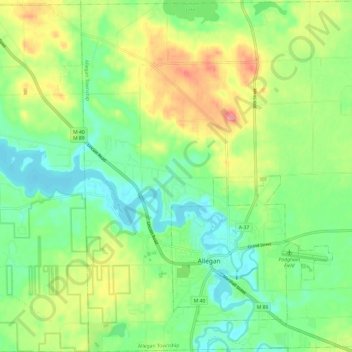
Name: Allegan Township topographic map, elevation, terrain.
Average elevation: 220 m
Minimum elevation: 186 m
Maximum elevation: 278 m
Other topographic maps
Click on a map to view its topography, its elevation and its terrain.
Allegan State Game Area
United States > Michigan > Allegan County > Allegan
Allegan State Game Area, Allegan, Clyde Township, Allegan County, Michigan, United States
Average elevation: 206 m
Hopkins
United States > Michigan > Allegan County
Hopkins, Hopkins Township, Allegan County, Michigan, 49328, United States
Average elevation: 216 m
Otsego Township
United States > Michigan > Allegan County
Otsego Township, Allegan County, Michigan, 49078, United States
Average elevation: 229 m
Pullman
United States > Michigan > Allegan County > Pullman
Pullman, Lee Township, Allegan County, Michigan, 49450, United States
Average elevation: 199 m
Cheshire Township
United States > Michigan > Allegan County
Cheshire Township, Allegan County, Michigan, United States
Average elevation: 218 m