
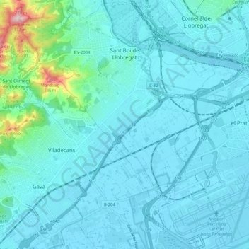
Sant Boi de Llobregat topographic map
Interactive map
Click on the map to display elevation.
About this map
Name: Sant Boi de Llobregat topographic map, elevation, terrain.
Average elevation: 34 m
Minimum elevation: -1 m
Maximum elevation: 322 m
Other topographic maps
Click on a map to view its topography, its elevation and its terrain.
Plaça de Montfalcone
Espagne > Catalogne > Bas-Llobrégat > Sant Just Desvern
Plaça de Montfalcone, Sant Just Desvern, Bas-Llobrégat, Barcelone, Catalogne, Espagne
Average elevation: 169 m
Gavà
Espagne > Catalogne > Bas-Llobrégat
Gavà, Bas-Llobrégat, Barcelone, Catalogne, 08850, Espagne
Average elevation: 59 m
Molins de Rei
Espagne > Catalogne > Bas-Llobrégat
Molins de Rei, Bas-Llobrégat, Barcelone, Catalogne, 08750, Espagne
Average elevation: 99 m