
เขตจอมทอง topographic map
Interactive map
Click on the map to display elevation.
About this map
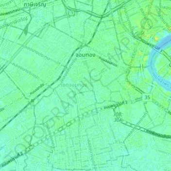
Name: เขตจอมทอง topographic map, elevation, terrain.
Location: เขตจอมทอง, Bangkok, 10150, Thaïlande (13.65908 100.43463 13.71792 100.48900)
Average elevation: 5 m
Minimum elevation: 0 m
Maximum elevation: 14 m
Other topographic maps
Click on a map to view its topography, its elevation and its terrain.
แขวงบางหว้า
Thaïlande > Bangkok > แขวงบางหว้า
แขวงบางหว้า, เขตภาษีเจริญ, Bangkok, 10160, Thaïlande
Average elevation: 5 m