
Berthenonville topographic map
Interactive map
Click on the map to display elevation.
About this map
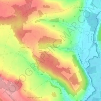
Name: Berthenonville topographic map, elevation, terrain.
Average elevation: 89 m
Minimum elevation: 27 m
Maximum elevation: 149 m
Other topographic maps
Click on a map to view its topography, its elevation and its terrain.
Forêt-la-Folie
France > Normandie > Vexin-sur-Epte
Forêt-la-Folie, Vexin-sur-Epte, Les Andelys, Eure, Normandie, France métropolitaine, 27510, France
Average elevation: 115 m