Lake Orion topographic map
Interactive map
Click on the map to display elevation.
About this map
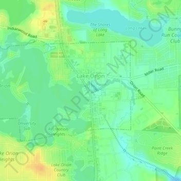
Name: Lake Orion topographic map, elevation, terrain.
Location: Lake Orion, Oakland County, Michigan, 48362, United States (42.77472 -83.25995 42.78982 -83.22865)
Average elevation: 303 m
Minimum elevation: 290 m
Maximum elevation: 320 m
Other topographic maps
Click on a map to view its topography, its elevation and its terrain.
Independence Charter Township
United States > Michigan > Oakland County
Independence Charter Township, Oakland County, Michigan, United States
Average elevation: 318 m
White Lake Charter Township
United States > Michigan > Oakland County
White Lake Charter Township, Oakland County, Michigan, United States
Average elevation: 303 m
Bloomfield Hills
United States > Michigan > Oakland County
Bloomfield Hills, Oakland County, Michigan, 48304, United States
Average elevation: 261 m
Highland Charter Township
United States > Michigan > Oakland County
Highland Charter Township, Oakland County, Michigan, 48357, United States
Average elevation: 315 m
Rochester
United States > Michigan > Oakland County
Rochester, Oakland County, Michigan, United States
Average elevation: 242 m
Troy
United States > Michigan > Oakland County
Troy, Oakland County, Michigan, United States
Average elevation: 221 m
Walled Lake
United States > Michigan > Oakland County
Walled Lake, Oakland County, Michigan, United States
Average elevation: 287 m
Greens Lake
United States > Michigan > Oakland County
Greens Lake, Oakland County, Michigan, United States
Average elevation: 309 m
Oakley Park
United States > Michigan > Oakland County > Commerce Charter Township
Oakley Park, Commerce Charter Township, Oakland County, Michigan, 48390, United States
Average elevation: 282 m
Rossman Lake
United States > Michigan > Oakland County
Rossman Lake, Oakland County, Michigan, United States
Average elevation: 314 m
Southfield
United States > Michigan > Oakland County
Southfield, Oakland County, Michigan, United States
Average elevation: 210 m
Huntington Woods
United States > Michigan > Oakland County
Huntington Woods, Oakland County, Michigan, 48070, United States
Average elevation: 204 m
Keego Harbor
United States > Michigan > Oakland County
Keego Harbor, Oakland County, Michigan, United States
Average elevation: 286 m
Auburn Hills
United States > Michigan > Oakland County
Auburn Hills, Oakland County, Michigan, 48326, United States
Average elevation: 284 m
Wixom
United States > Michigan > Oakland County > Wixom
Wixom, Oakland County, Michigan, United States
Average elevation: 288 m
Novi
United States > Michigan > Oakland County
Novi, Oakland County, Michigan, United States
Average elevation: 280 m
Pleasant Ridge
United States > Michigan > Oakland County > Pleasant Ridge
Pleasant Ridge, Oakland County, Michigan, United States
Average elevation: 201 m
Royal Oak
United States > Michigan > Oakland County
Royal Oak, Oakland County, Michigan, United States
Average elevation: 203 m
South Lyon
United States > Michigan > Oakland County > South Lyon
South Lyon, Oakland County, Michigan, United States
Average elevation: 282 m
Orion Charter Township
United States > Michigan > Oakland County
Orion Charter Township, Oakland County, Michigan, United States
Average elevation: 306 m
Lakeville
United States > Michigan > Oakland County > Lakeville
Lakeville, Oakland County, Michigan, 48366, United States
Average elevation: 299 m
Pontiac
United States > Michigan > Oakland County
Pontiac, Oakland County, Michigan, United States
Average elevation: 290 m