
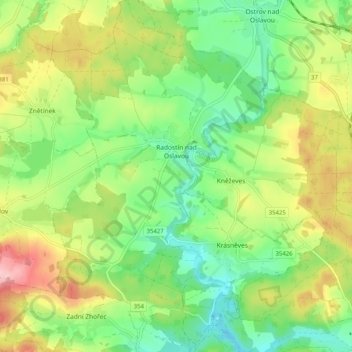
Radostín nad Oslavou topographic map
Interactive map
Click on the map to display elevation.
About this map
Name: Radostín nad Oslavou topographic map, elevation, terrain.
Average elevation: 551 m
Minimum elevation: 483 m
Maximum elevation: 656 m
Other topographic maps
Click on a map to view its topography, its elevation and its terrain.
Lány
Czechia > Southeast > Kraj Vysočina
Lány, okres Havlíčkův Brod, Kraj Vysočina, Southeast, Czechia
Average elevation: 469 m
Třebíč
Czechia > Southeast > Kraj Vysočina
Třebíč, okres Třebíč, Kraj Vysočina, Southeast, 674 01, Czechia
Average elevation: 479 m
Nové Město na Moravě
Czechia > Southeast > Kraj Vysočina
Nové Město na Moravě, okres Žďár nad Sázavou, Kraj Vysočina, Southeast, 592 31, Czechia
Average elevation: 655 m
Pávov
Czechia > Southeast > Kraj Vysočina > Jihlava
Pávov, Jihlava, okres Jihlava, Kraj Vysočina, Southeast, 588 11, Czechia
Average elevation: 525 m
Křídla
Czechia > Southeast > Kraj Vysočina > Křídla
Křídla, okres Žďár nad Sázavou, Kraj Vysočina, Southeast, Czechia
Average elevation: 600 m
Popůvky
Czechia > Southeast > Kraj Vysočina > Popůvky
Popůvky, okres Třebíč, Kraj Vysočina, Southeast, Czechia
Average elevation: 440 m
Strážek
Czechia > Southeast > Kraj Vysočina
Strážek, okres Žďár nad Sázavou, Kraj Vysočina, Southeast, 592 53, Czechia
Average elevation: 506 m