
Telluride topographic map
Interactive map
Click on the map to display elevation.
About this map
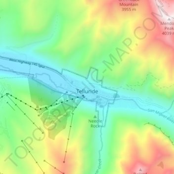
Name: Telluride topographic map, elevation, terrain.
Average elevation: 3,125 m
Minimum elevation: 2,647 m
Maximum elevation: 4,023 m
Other topographic maps
Click on a map to view its topography, its elevation and its terrain.
Telluride
Vereinigte Staaten von Amerika > Colorado > San Miguel County > Telluride
Telluride, San Miguel County, Colorado, 8145, Vereinigte Staaten von Amerika
Average elevation: 3,246 m