
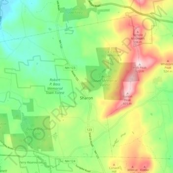
Sharon topographic map
Interactive map
Click on the map to display elevation.
About this map
Name: Sharon topographic map, elevation, terrain.
Location: Sharon, Hillsborough County, New Hampshire, United States (42.78833 -71.98422 42.84740 -71.88532)
Average elevation: 380 m
Minimum elevation: 234 m
Maximum elevation: 615 m
The topography is uneven and, in parts, mountainous. In 1823, the population was 400. By 1859, when the population was 229, the town had three sawmills. The principal occupation, however, was farming.
Other topographic maps
Click on a map to view its topography, its elevation and its terrain.
Manchester
United States > New Hampshire > Hillsborough County
Manchester, Hillsborough County, New Hampshire, United States
Average elevation: 96 m
Nashua
United States > New Hampshire > Hillsborough County
Nashua, Hillsborough County, New Hampshire, United States
Average elevation: 62 m
Bedford
United States > New Hampshire > Hillsborough County
Bedford, Hillsborough County, New Hampshire, 03110, United States
Average elevation: 97 m
West Peterborough
United States > New Hampshire > Hillsborough County > Peterborough
West Peterborough, Peterborough, Hillsborough County, New Hampshire, 03468, United States
Average elevation: 299 m
Lyndeborough
United States > New Hampshire > Hillsborough County
Lyndeborough, Hillsborough County, New Hampshire, 03082, United States
Average elevation: 245 m
East Merrimack
United States > New Hampshire > Hillsborough County > Merrimack
East Merrimack, Merrimack, Hillsborough County, New Hampshire, 03054, United States
Average elevation: 55 m
Pinardville
United States > New Hampshire > Hillsborough County > Goffstown
Pinardville, Goffstown, Hillsborough County, New Hampshire, 03102, United States
Average elevation: 86 m
Grasmere
United States > New Hampshire > Hillsborough County > Goffstown
Grasmere, Goffstown, Hillsborough County, New Hampshire, 03045, United States
Average elevation: 115 m
Reeds Ferry
United States > New Hampshire > Hillsborough County > Merrimack
Reeds Ferry, Merrimack, Hillsborough County, New Hampshire, 03054, United States
Average elevation: 58 m
Amherst
United States > New Hampshire > Hillsborough County
Amherst, Hillsborough County, New Hampshire, 03031, United States
Average elevation: 127 m
Horace Lake
United States > New Hampshire > Hillsborough County > Weare
Horace Lake, Weare, Hillsborough County, New Hampshire, United States
Average elevation: 245 m
New Ipswich
United States > New Hampshire > Hillsborough County
New Ipswich, Hillsborough County, New Hampshire, 03071, United States
Average elevation: 339 m
New Boston
United States > New Hampshire > Hillsborough County
New Boston, Hillsborough County, New Hampshire, 03070, United States
Average elevation: 192 m
Pelham
United States > New Hampshire > Hillsborough County
Pelham, Hillsborough County, New Hampshire, 03076, United States
Average elevation: 69 m
Goffstown
United States > New Hampshire > Hillsborough County
Goffstown, Hillsborough County, New Hampshire, 03045, United States
Average elevation: 159 m
Weare
United States > New Hampshire > Hillsborough County
Weare, Hillsborough County, New Hampshire, United States
Average elevation: 210 m
Peterborough
United States > New Hampshire > Hillsborough County
Peterborough, Hillsborough County, New Hampshire, United States
Average elevation: 304 m
Brookline
United States > New Hampshire > Hillsborough County
Brookline, Hillsborough County, New Hampshire, 03033, United States
Average elevation: 126 m
Merrimack River
United States > New Hampshire > Hillsborough County > Nashua
Merrimack River, Ward 3, Nashua, Hillsborough County, New Hampshire, United States
Average elevation: 77 m
Antrim
United States > New Hampshire > Hillsborough County
Antrim, Hillsborough County, New Hampshire, 03440, United States
Average elevation: 289 m
Shipley Hill
United States > New Hampshire > Hillsborough County > Nashua
Shipley Hill, Nashua, Hillsborough County, New Hampshire, 03039, United States
Average elevation: 77 m
Joe English Hill
United States > New Hampshire > Hillsborough County > New Boston
Joe English Hill, New Boston, Hillsborough County, New Hampshire, 03070, United States
Average elevation: 247 m
Hudson
United States > New Hampshire > Hillsborough County
Hudson, Hillsborough County, New Hampshire, 03051, United States
Average elevation: 68 m
Hollis
United States > New Hampshire > Hillsborough County
Hollis, Hillsborough County, New Hampshire, United States
Average elevation: 101 m
Gibson Four Corners
United States > New Hampshire > Hillsborough County > New Ipswich
Gibson Four Corners, New Ipswich, Hillsborough County, New Hampshire, 03071, United States
Average elevation: 328 m
Litchfield
United States > New Hampshire > Hillsborough County
Litchfield, Hillsborough County, New Hampshire, 03052, United States
Average elevation: 67 m
Riverdale
United States > New Hampshire > Hillsborough County > New Boston
Riverdale, New Boston, Hillsborough County, New Hampshire, United States
Average elevation: 131 m
Hancock
United States > New Hampshire > Hillsborough County
Hancock, Hillsborough County, New Hampshire, 03449, United States
Average elevation: 300 m
Nashua
United States > New Hampshire > Hillsborough County > Nashua
Nashua, Hillsborough County, New Hampshire, 03060-03064, United States
Average elevation: 82 m
Greenville
United States > New Hampshire > Hillsborough County
Greenville, Hillsborough County, New Hampshire, United States
Average elevation: 288 m
Mason
United States > New Hampshire > Hillsborough County
Mason, Hillsborough County, New Hampshire, 03048, United States
Average elevation: 229 m
Mountain Base
United States > New Hampshire > Hillsborough County > Goffstown
Mountain Base, Goffstown, Hillsborough County, New Hampshire, 03045, United States
Average elevation: 207 m
Massabesic Lake
United States > New Hampshire > Hillsborough County > Manchester
Massabesic Lake, Manchester, Hillsborough County, New Hampshire, United States
Average elevation: 90 m
Cricket Corner
United States > New Hampshire > Hillsborough County > Amherst
Cricket Corner, Amherst, Hillsborough County, New Hampshire, 03031, United States
Average elevation: 78 m
Deering
United States > New Hampshire > Hillsborough County
Deering, Hillsborough County, New Hampshire, United States
Average elevation: 274 m
Temple
United States > New Hampshire > Hillsborough County
Temple, Hillsborough County, New Hampshire, 03084, United States
Average elevation: 346 m
Mont Vernon
United States > New Hampshire > Hillsborough County
Mont Vernon, Hillsborough County, New Hampshire, 03057, United States
Average elevation: 195 m
Hillsborough
United States > New Hampshire > Hillsborough County
Hillsborough, Hillsborough County, New Hampshire, 03244, United States
Average elevation: 298 m
Manchester
United States > New Hampshire > Hillsborough County > Manchester
Manchester, Hillsborough County, New Hampshire, 03108, United States
Average elevation: 126 m
Wilton
United States > New Hampshire > Hillsborough County
Wilton, Hillsborough County, New Hampshire, 03086, United States
Average elevation: 178 m
Merrimack
United States > New Hampshire > Hillsborough County
Merrimack, Hillsborough County, New Hampshire, 03054, United States
Average elevation: 68 m
Bennington
United States > New Hampshire > Hillsborough County
Bennington, Hillsborough County, New Hampshire, 03442, United States
Average elevation: 260 m
Hillsborough
United States > New Hampshire > Hillsborough County
Hillsborough, Hillsborough County, New Hampshire, 03244, United States
Average elevation: 253 m
Francestown
United States > New Hampshire > Hillsborough County
Francestown, Hillsborough County, New Hampshire, United States
Average elevation: 276 m
Milford
United States > New Hampshire > Hillsborough County
Milford, Hillsborough County, New Hampshire, 03055, United States
Average elevation: 114 m
Windsor
United States > New Hampshire > Hillsborough County
Windsor, Hillsborough County, New Hampshire, United States
Average elevation: 375 m
Greenfield
United States > New Hampshire > Hillsborough County
Greenfield, Hillsborough County, New Hampshire, 03047, United States
Average elevation: 288 m
MacDowell Colony
United States > New Hampshire > Hillsborough County > Peterborough
MacDowell Colony, Peterborough, Hillsborough County, New Hampshire, 03458, United States
Average elevation: 261 m