Geolocate

Mount Bogong topographic map

Click on the map to display elevation.

Mount Bogong

The Big River separates the massif of the mountain from the Bogong High Plains to the south. From the nearby town of Mount Beauty to its summit, Mount Bogong rises more than 1,600 metres (5,200 ft), thus making it one of the highest peaks in Australia not only in terms of its elevation above sea level, but also in terms of actual base-to-summit prominence.

Wikipedia (CC-BY-SA 3.0)

About this map

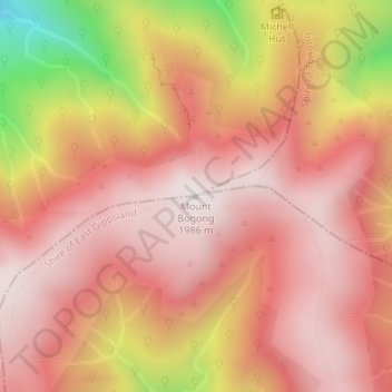
Name: Mount Bogong topographic map, elevation, terrain.

Location: Mount Bogong, Shire of East Gippsland, Victoria, Australia (-36.73242 147.30578 -36.73232 147.30588)

Average elevation: 1,719 m

Minimum elevation: 1,109 m

Maximum elevation: 1,985 m

Other topographic maps

Click on a map to view its topography, its elevation and its terrain.

City of Melbourne

Australia > Victoria

Melbourne's topography is characterized by a diverse landscape that transitions from flat coastal plains to rolling hills and mountainous regions. The city is situated at the northern end of Port Phillip Bay, where the terrain is predominantly flat, facilitating urban development. As one moves eastward, the…

Average elevation: 18 m

Melbourne

Australia > Victoria

Melbourne is also prone to isolated convective showers forming when a cold pool crosses the state, especially if there is considerable daytime heating. These showers are often heavy and can include hail, squalls, and significant drops in temperature, but they often pass through very quickly with a rapid…

Average elevation: 185 m

Glen Waverley

Australia > Victoria

Average elevation: 103 m

Dandenong Ranges National Park - Ferntree Gully

Australia > Victoria > Montrose

The topography consists of a series of ridges dissected by deeply cut streams. Sheltered gullies in the south of the range are home to temperate rain forest, fern gullies and Mountain Ash forest Eucalyptus regnans, whereas the drier ridges and exposed northern slopes are covered by dry sclerophyll forest of…

Average elevation: 345 m

Grampians National Park

Australia > Victoria

Mount William is known within the gliding community for the "Grampians Wave", a weather phenomenon that sometimes enables glider pilots to reach extreme altitudes of the order of 28,000 ft (8,500 m). This predominantly occurs during the months of May, June, September and October when strong westerly winds flow…

Average elevation: 262 m

Greensborough

Australia > Victoria

Average elevation: 83 m

Mount Buller

Australia > Victoria

Due to its far south-western location in the alpine region, Mount Buller is more susceptible to cold airmasses which allow it to record some of the lowest maximum temperatures and daytime readings in the country, despite being considerably lower in elevation than other mountain sites to the north-east. On 5…

Average elevation: 824 m

Warrnambool

Australia > Victoria

Average elevation: 19 m

Lakes Entrance

Australia > Victoria

Average elevation: 39 m

Elwood

Australia > Victoria > Melbourne

Average elevation: 8 m

Gippsland

Australia > Victoria

Average elevation: 273 m

Smiths Beach

Australia > Victoria

Average elevation: 24 m

Fitzroy

Australia > Victoria > Melbourne

Fitzroy's topography is flat. It is laid out in grid plan and is characterised by a fairly tightly spaced rectangular grid of medium-sized streets, with many of its narrow streets and back lanes facilitating only one-way traffic. Its built form is a legacy of its early history when a mixture of land uses was…

Average elevation: 35 m

Point Cook

Australia > Victoria > Melbourne

Average elevation: 8 m

Flowerdale

Australia > Victoria

Average elevation: 402 m

Glen Iris

Australia > Victoria

Average elevation: 46 m

Omeo

Australia > Victoria

There are bus routes from Bright and Bairnsdale. The Bairnsdale bus runs weekdays, once both directions, and the Bright bus (Alps Link) timetable is less frequent in Summer and runs additional services during the ski season. Alps Link is the highest altitude public bus in Australia. The town sits at the…

Average elevation: 861 m

Frankston

Australia > Victoria

Olivers Hill is the most prominent elevation in Frankston which rises to 55 metres above sea level (180 feet) at its highest point in the suburb. Its origins date to approximately 415 to 360 million years ago. Its base is Mount Eliza Granite dating from the Devonian period, which was covered in lava tuffs in…

Average elevation: 40 m

Great Otway National Park

Australia > Victoria

Average elevation: 91 m

Woodend

Australia > Victoria

Average elevation: 603 m

Inverloch

Australia > Victoria

Average elevation: 27 m

Wabonga

Australia > Victoria

Average elevation: 904 m

Hinnomunjie

Australia > Victoria

Average elevation: 742 m

Tarwin Lower

Australia > Victoria

Average elevation: 28 m

Warburton

Australia > Victoria

Average elevation: 525 m

Doncaster East

Australia > Victoria

Average elevation: 89 m

Aberfeldie

Australia > Victoria > Melbourne

Average elevation: 27 m

Maribyrnong

Australia > Victoria

Average elevation: 23 m

Altona North

Australia > Victoria > Melbourne

Average elevation: 15 m

Keilor

Australia > Victoria > Melbourne

Average elevation: 72 m

Dingley Village

Australia > Victoria

Average elevation: 26 m

Eltham District

Australia > Victoria > Greensborough

Average elevation: 85 m

Harrietville

Australia > Victoria

Average elevation: 1,018 m

Bittern

Australia > Victoria > Melbourne

Average elevation: 24 m

Drouin

Australia > Victoria

Average elevation: 121 m

Shire of Mansfield

Australia > Victoria

Average elevation: 748 m

French Island

Australia > Victoria

Average elevation: 12 m

Mordialloc

Australia > Victoria

Average elevation: 10 m

Wheelers Hill

Australia > Victoria

Average elevation: 85 m

Echuca

Australia > Victoria

Average elevation: 100 m

Halls Gap

Australia > Victoria

Average elevation: 406 m

Yackandandah

Australia > Victoria

Average elevation: 469 m

Torquay

Australia > Victoria

Average elevation: 32 m

Blackburn

Australia > Victoria

Average elevation: 103 m

Wandiligong

Australia > Victoria

Average elevation: 657 m

Port Phillip

Australia > Victoria

Port Phillip's mostly flat topography and moderate waves make perfect conditions for recreational swimming, kitesurfing, windsurfing, sailing, boating, snorkeling, scuba diving, stand up paddle boarding (SUP) and other sports.

Average elevation: 18 m

Chadstone

Australia > Victoria

Average elevation: 67 m

Port Fairy

Australia > Victoria

Average elevation: 22 m

Lerderderg State Park

Australia > Victoria

Average elevation: 459 m

Newstead

Australia > Victoria

Average elevation: 247 m

Forrest

Australia > Victoria

Hemmed in by a rising ocean that stabilised about 7000 years ago, the uplifted sedimentary rocks of the Otway Range run from north-east to south-west at an elevation of about 500 metres above the sea. A few isolated peaks reach up to 675 metres, and at many points along this coastline bare mountains and…

Average elevation: 212 m

Matlock

Australia > Victoria

Average elevation: 889 m

Longwarry North

Australia > Victoria

Average elevation: 55 m

Woods Point

Australia > Victoria

Average elevation: 878 m

Barwon Downs

Australia > Victoria

Average elevation: 279 m

Morrisons

Australia > Victoria

Average elevation: 372 m

Mount Beauty

Australia > Victoria

The town has a prominent winter rainfall peak, with a yearly average of 1,264.6 millimetres (49.79 in). It rains on 142 days of the year; heavily concentrated between May and October. On account of its southern latitude nearing the 37th parallel, summers have a notable chill about them when compared to…

Average elevation: 884 m

Cann River

Australia > Victoria

Average elevation: 111 m

Balook

Australia > Victoria

Average elevation: 432 m

Wodonga

Australia > Victoria

Average elevation: 191 m

Hawthorn

Australia > Victoria > Melbourne

Average elevation: 33 m

Alphington

Australia > Victoria

Average elevation: 35 m

Armstrong Creek

Australia > Victoria > Geelong

Average elevation: 47 m

Moe

Australia > Victoria

Average elevation: 79 m

Mornington District

Australia > Victoria > Melbourne

Average elevation: 50 m

Templestowe

Australia > Victoria > Melbourne

Gentle, rolling hills extend from east of the Yarra River flood plains, along Templestowe Road (towards the Eastern Freeway) for seven km (4.3 miles), to the north-east. The altitude of the plain above sea level is 50 m, and the topography is subdued and mostly flat; the hills are just below 60 m, the slopes…

Average elevation: 66 m

Traralgon

Australia > Victoria

Average elevation: 53 m

Hastings District

Australia > Victoria > Koo Wee Rup > Clyde

Average elevation: 14 m

Kilmore

Australia > Victoria

Average elevation: 349 m

Mount Evelyn

Australia > Victoria

Average elevation: 189 m

Lake Eildon National Park

Australia > Victoria

Average elevation: 473 m

Bendigo Creek

Australia > Victoria > Bendigo

Average elevation: 227 m

Lake Eildon

Australia > Victoria

Average elevation: 386 m

Lake Eppalock

Australia > Victoria

Average elevation: 219 m

Swan Hill

Australia > Victoria

Average elevation: 72 m

Cobungra

Australia > Victoria

Average elevation: 1,124 m

West Melbourne

Australia > Victoria > Melbourne

Average elevation: 8 m

Knoxfield

Australia > Victoria > Melbourne

Average elevation: 80 m

Olinda

Australia > Victoria > Melbourne

Average elevation: 370 m

Kew

Australia > Victoria > Melbourne

Average elevation: 38 m

Wonthaggi

Australia > Victoria

Average elevation: 23 m

Cape Paterson

Australia > Victoria

Average elevation: 29 m

Port Melbourne

Australia > Victoria > Melbourne

Average elevation: 4 m

Diamond Creek

Australia > Victoria

Average elevation: 75 m

Kyneton

Australia > Victoria

Average elevation: 504 m

Docklands

Australia > Victoria

Average elevation: 9 m

Mount Eliza

Australia > Victoria > Melbourne

Average elevation: 60 m

Bright

Australia > Victoria

Average elevation: 550 m

Donvale

Australia > Victoria > Melbourne

Average elevation: 108 m

Thornbury

Australia > Victoria

Average elevation: 54 m

Kinglake National Park

Australia > Victoria > Kinglake

Average elevation: 358 m

Portland

Australia > Victoria

Average elevation: 20 m

Shire of South Gippsland

Australia > Victoria

Average elevation: 81 m

Morwell

Australia > Victoria

Average elevation: 61 m

Huntly

Australia > Victoria

Average elevation: 180 m

Melton

Australia > Victoria > Melbourne

Average elevation: 146 m

Mt Taylor

Australia > Victoria

Average elevation: 217 m

Tawonga South

Australia > Victoria

Average elevation: 752 m