
Piedemonte topographic map
Interactive map
Click on the map to display elevation.
About this map
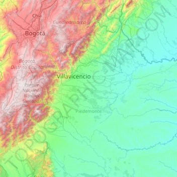
Name: Piedemonte topographic map, elevation, terrain.
Location: Piedemonte, Meta, RAP (Especial) Central, Colombia (3.23924 -74.39864 4.73721 -72.27940)
Average elevation: 1,025 m
Minimum elevation: 151 m
Maximum elevation: 4,151 m
Other topographic maps
Click on a map to view its topography, its elevation and its terrain.
La Suiza
Colombia > Meta > Villavicencio
La Suiza, Villavicencio, Capital, Meta, Colombia
Average elevation: 466 m
Caserío La Victoria
Colombia > Meta > Puerto López > Caserío La Victoria
Caserío La Victoria, Puerto López, Rio Meta, Meta, Colombia
Average elevation: 192 m