
Águas de Moura topographic map
Interactive map
Click on the map to display elevation.
About this map
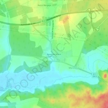
Name: Águas de Moura topographic map, elevation, terrain.
Average elevation: 25 m
Minimum elevation: -2 m
Maximum elevation: 68 m
Other topographic maps
Click on a map to view its topography, its elevation and its terrain.
Fernando Pó
Fernando Pó, Poceirão e Marateca, Palmela, Setúbal, 2965-572, Portugal
Average elevation: 52 m
Quinta do Anjo
Quinta do Anjo, Palmela, Setúbal, Portugal
Average elevation: 68 m
Lagoa do Calvo
Portugal > Setúbal > Palmela > Lagoa do Calvo
Lagoa do Calvo, Poceirão e Marateca, Palmela, Setúbal, Portugal
Average elevation: 41 m
Quinta do Anjo
Quinta do Anjo, Palmela, Setúbal, 2950-752, Portugal
Average elevation: 108 m