
Mouligneau topographic map
Interactive map
Click on the map to display elevation.
About this map
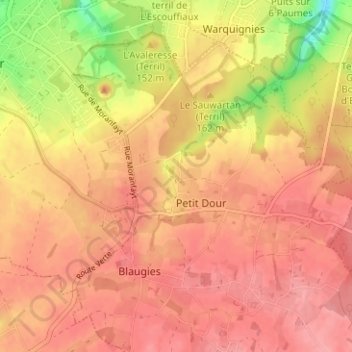
Name: Mouligneau topographic map, elevation, terrain.
Location: Mouligneau, Dour, Mons, Hainaut, Wallonie, 7370, Belgique (50.36355 3.79201 50.40355 3.83201)
Average elevation: 119 m
Minimum elevation: 60 m
Maximum elevation: 144 m
Other topographic maps
Click on a map to view its topography, its elevation and its terrain.
Cité Chevalière
Belgique > Hainaut > Mons > Dour
Cité Chevalière, Dour, Mons, Hainaut, Wallonie, 7370, Belgique
Average elevation: 104 m
Petit Dour
Belgique > Hainaut > Mons > Dour
Petit Dour, Mons, Hainaut, Wallonie, 7370, Belgique
Average elevation: 122 m