
Pinedale topographic map
Interactive map
Click on the map to display elevation.
About this map
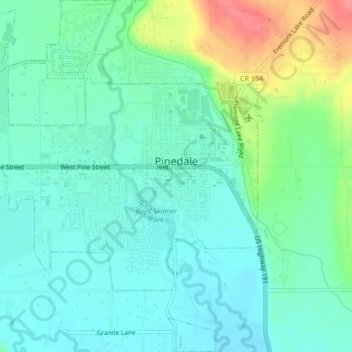
Name: Pinedale topographic map, elevation, terrain.
Location: Pinedale, Sublette County, Wyoming, 82941, United States (42.85040 -109.89102 42.88123 -109.85054)
Average elevation: 2,196 m
Minimum elevation: 2,175 m
Maximum elevation: 2,252 m
Pinedale is located at 42°51′58″N 109°51′53″W / 42.86611°N 109.86472°W / 42.86611; -109.86472 (42.866162, −109.864622) and sits at an elevation of 7,175 feet above sea level. According to the United States Census Bureau, the town has a total area of 2.15 square miles (5.57 km2), all land.
Other topographic maps
Click on a map to view its topography, its elevation and its terrain.
Downs Mountain
United States > Wyoming > Sublette County
Downs Mountain, Sublette County, Wyoming, United States
Average elevation: 3,777 m
Big Sandy Lake
United States > Wyoming > Sublette County
Big Sandy Lake, Sublette County, Wyoming, United States
Average elevation: 3,103 m
Pine Creek
United States > Wyoming > Sublette County > Pinedale
Pine Creek, Pinedale, Sublette County, Wyoming, 82941, United States
Average elevation: 2,188 m
Bridger Wilderness
United States > Wyoming > Sublette County
Bridger Wilderness, Sublette County, Wyoming, United States
Average elevation: 2,677 m