
Make a donation
Sumter County topographic map
Click on the map to display elevation.
Make a donation
About this map
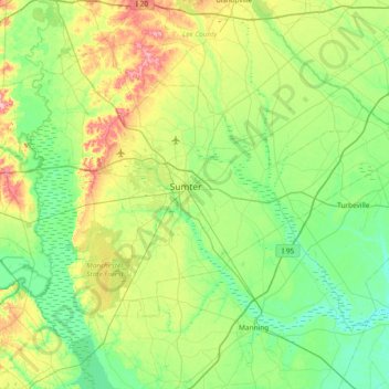
Name: Sumter County topographic map, elevation, terrain.
Location: Sumter County, South Carolina, United States (33.64378 -80.64082 34.16876 -79.89262)
Average elevation: 47 m
Minimum elevation: 12 m
Maximum elevation: 143 m
Make a donation
Other topographic maps
Click on a map to view its topography, its elevation and its terrain.
Orange Grove Estates
United States > South Carolina > Charleston County > Charleston
Average elevation: 4 m
Make a donation
Palmetto Fort
United States > South Carolina > Charleston County > Mount Pleasant
Average elevation: 4 m
Make a donation
Make a donation
Make a donation
Garden Hill
United States > South Carolina > Charleston County > Charleston > Garden Hill
Average elevation: 3 m
Garden City Beach
United States > South Carolina > Horry County > Garden City Beach
Average elevation: 4 m
Make a donation
Sea Pines
United States > South Carolina > Beaufort County > Hilton Head Island > Sea Pines
Average elevation: 4 m
Sansbury Crossroads
United States > South Carolina > Florence County > Sansbury Crossroads
Average elevation: 38 m
Make a donation
Belleview
United States > South Carolina > Richland County > Columbia > Belleview
Average elevation: 79 m
Spartanburg
United States > South Carolina > Spartanburg County > Spartanburg
Average elevation: 234 m
Make a donation
Warington
United States > South Carolina > Dorchester County > Summerville > Warington
Average elevation: 23 m