
Thank you for supporting this site ❤️
Make a donation
Make a donation
West Hoathly topographic map
Click on the map to display elevation.
Thank you for supporting this site ❤️
Make a donation
Make a donation
About this map
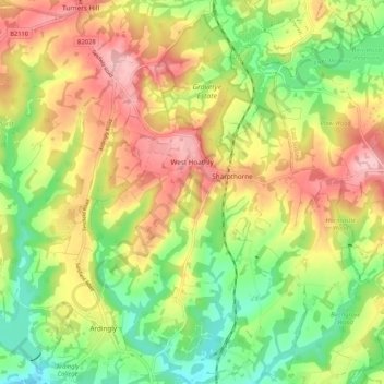
Name: West Hoathly topographic map, elevation, terrain.
Location: West Hoathly, West Sussex, England, United Kingdom (51.03878 -0.09023 51.10501 -0.00979)
Average elevation: 112 m
Minimum elevation: 38 m
Maximum elevation: 193 m
Thank you for supporting this site ❤️
Make a donation
Make a donation
Other topographic maps
Click on a map to view its topography, its elevation and its terrain.