
Kandi topographic map
Interactive map
Click on the map to display elevation.
About this map
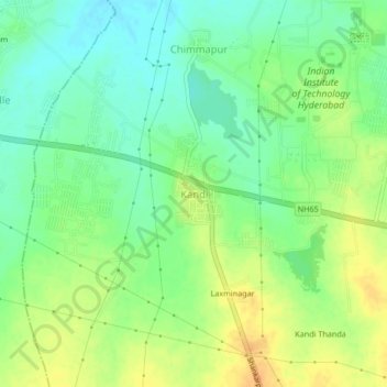
Name: Kandi topographic map, elevation, terrain.
Location: Kandi, Kandi mandal, Sangareddy, Telangana, 502285, India (17.56127 78.08845 17.60127 78.12845)
Average elevation: 529 m
Minimum elevation: 513 m
Maximum elevation: 547 m
Other topographic maps
Click on a map to view its topography, its elevation and its terrain.
Cheriyal
India > Telangana > Kandi mandal
Cheriyal, Kandi mandal, Sangareddy, Telangana, 502329, India
Average elevation: 547 m
Kasipur
India > Telangana > Kandi mandal > Kasipur
Kasipur, Kandi mandal, Sangareddy, Telangana, 502285, India
Average elevation: 545 m