
Taitung City topographic map
Interactive map
Click on the map to display elevation.
About this map
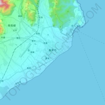
Name: Taitung City topographic map, elevation, terrain.
Location: Taitung City, Taitung County, Taiwan Province, 950, Taiwan (22.68389 121.02599 22.81964 121.20051)
Average elevation: 41 m
Minimum elevation: -1 m
Maximum elevation: 803 m
Other topographic maps
Click on a map to view its topography, its elevation and its terrain.
Orchid Island
Taiwan > Taiwan Province > Taitung County > Orchid Island
Orchid Island, Taitung County, Taiwan Province, Taiwan
Average elevation: 76 m