
Thank you for supporting this site ❤️
Make a donation
Make a donation
Meuse topographic map
Click on the map to display elevation.
Thank you for supporting this site ❤️
Make a donation
Make a donation
About this map
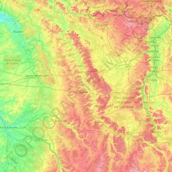
Name: Meuse topographic map, elevation, terrain.
Location: Meuse, Grand Est, Metropolitan France, France (48.40910 4.88846 49.61693 5.85422)
Average elevation: 240 m
Minimum elevation: 78 m
Maximum elevation: 531 m
Thank you for supporting this site ❤️
Make a donation
Make a donation
Other topographic maps
Click on a map to view its topography, its elevation and its terrain.
city de boutet de monvel (ethanlecartographe
France > Grand Est > Meurthe-et-Moselle > Lunéville
Average elevation: 240 m
Thank you for supporting this site ❤️
Make a donation
Make a donation
Thank you for supporting this site ❤️
Make a donation
Make a donation