
Make a donation
Wuppertal topographic map
Click on the map to display elevation.
Make a donation
Wuppertal
Uniquely for Germany, it is a "linear city", owing to the steep hillsides along the river Wupper. Its highest hill is the Lichtscheid, which is 351 m (1,152 ft) above sea level. The dominant urban centres Elberfeld (historic commercial centre) and Barmen (more industrial) have formed a continuous urbanized area since 1850. During the succeeding decades, "Wupper-Town" became the dominant industrial agglomeration of northwestern Germany. During the 20th century, this conurbation had been surpassed by Cologne, Düsseldorf and the Ruhr area, all with a more favourable topography.
Make a donation
About this map
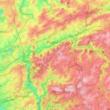
Name: Wuppertal topographic map, elevation, terrain.
Location: Wuppertal, North Rhine-Westphalia, Germany (51.16572 7.01407 51.31810 7.31343)
Average elevation: 242 m
Minimum elevation: 87 m
Maximum elevation: 380 m
Make a donation
Other topographic maps
Click on a map to view its topography, its elevation and its terrain.
Bend
Germany > North Rhine-Westphalia > Städteregion Aachen > Stolberg > Schevenhütte
Average elevation: 267 m
Make a donation
Bochum
Germany > North Rhine-Westphalia > Bochum
The city lies on the low rolling hills of Bochum land ridge (Bochumer Landrücken), part of the Ruhrhöhen (highest elevations) between the Ruhr and Emscher rivers at the border of the southern and northern Ruhr coal region. The highest point of the city is at Kemnader Straße (Kemnader Street) in Stiepel at…
Average elevation: 107 m