
Potosí topographic map
Interactive map
Click on the map to display elevation.
Potosí
Potosí features a rare climate for a city of its size, due to its extreme elevation at over 4000m. Semiarid and with average temperatures in its warmest month sitting right on the 10 °C threshold, the city's climate straddles that of the subtropical highland climate (Cwc, according to the Köppen climate classification), with subpolar oceanic characteristics and an alpine climate (E). Summers are cool and wet with daily highs rarely rising above 20 °C, while winters feature cooler days with much colder nights averaging −4 °C. These low temperatures are a result of the extreme precipitation deficit during the winter months with the resulting aridity leading to an increased diurnal temperature variation.
About this map
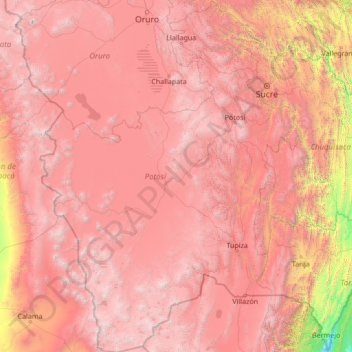
Name: Potosí topographic map, elevation, terrain.
Location: Potosí, Bolivia (-22.89827 -68.77370 -17.80086 -64.71463)
Average elevation: 3,383 m
Minimum elevation: 385 m
Maximum elevation: 6,321 m
Other topographic maps
Click on a map to view its topography, its elevation and its terrain.
Morning Sun
Bolivia > Potosí > Provincia Sur Lípez > Municipio San Pablo de Lipez
Sol de Mañana is an area with geothermal manifestations in southern Bolivia, including fumaroles, hot springs and mud pools. It lies at about 4,900 metres (16,100 ft) elevation, south of Laguna Colorada and east of El Tatio geothermal field. The field is located within the Eduardo Avaroa Andean Fauna National…
Average elevation: 4,894 m
Santiago de Agencha
Bolivia > Potosí > Provincia Nor Lípez > Municipio Colcha K
Average elevation: 3,792 m
San Pedro de Quemes
Bolivia > Potosí > Provincia Nor Lípez > Municipio San Pedro de Quemes
Average elevation: 3,710 m
Huayajara
Bolivia > Potosí > Provincia Sur Lípez > Municipio San Pablo de Lipez
Average elevation: 4,370 m